This is a subscription only section
Want to read more? It's only €10/year.
No account yet? Just Create an account first and head to the shop
This is a subscription only section
Want to read more? It's only €10/year.
| ICAO Code | KMGE/MGE |
| Last Validated | |
| City | Marietta, GA |
| Position | 33°54'55"N 084°30'59"W |
| Runway(s) | 11/29 |
| Elevation | 1068 ft |
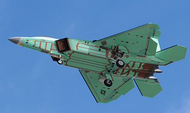
Dobbins ARB is along the highway 41 in Marietta. It's possible to get good photos at either end. The runway is oriented NW/SE (11/29). Dobbins Joint Air Reserve Base is the largest multi-service reserve training base in the world. Dobbins Joint Air Reserve Base was built in 1943 and was originally called Marietta Army Airfield. Dobbins was used as an aircraft assembly plant (Marietta Aircraft Assembly Plant) but in 1943, the base was designated Marietta Army Airfield aka Cobb County Airport. In 1944, it was transferred from the Army to the Air Force. and was named as Marietta Air Force Base. In 1950 the name changed to Dobbins Air Force Base to honour Capt. Charles Dobbins, a flyer from Marietta who was killed in July 1943 when his aircraft was shot down over the Mediterranean Sea. In June 1992, the name was changed to Dobbins Air Reserve Base. Adjacent to Dobbins is Naval Air Station Atlanta, also used by the US Army. Also sharing the Dobbins runway is Lockheed Martin Aeronautical Systems Plant No. 6 which includes a 74-acre building where Lockheed builds the C-130 Hercules and F-22.
The airport has a corner for all its users. North of the runway, on the east side, close to spot 3, there is the apron for the AFRC. North of the runway, just south of Plant 6 is the area for the US Army. South of the runway are many aprons for the Lockheed Martin aircraft, C-130 and F-22.
Dobbins JARB complex is located in Marietta, Georgia, off Exit 261, Highway 75, 16 miles northwest of Atlanta and about 25 miles from the Atlanta IAP.
Parking your car is no problem at the parking of the Walmart, near spot 3, next to taking pictures like this one. Photo Ben Uffen
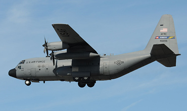
If you stand at spot 2, at the beginning of the Airport Industrial Park Drive, you can take these pictures of Hercules. Photo Ben Uffen
| 125.300/275.800 | Ground |
| 120.750/370.875 | Tower |
| 121.000/268.700 | Approach/Departure |
| 269.500 | ATIS |
| 700th AS AFRC | C-130H |
| 1/151 AVN REGT Georgia ArNG | OH-58A+ |
| 1/171 AVN REGT Georgia ArNG | UH-60L |
| OSACAM det.9 | C-26E |
| LMTAS | C-130, F-22 |
| Aviation Wing Marietta MoH | multiple |
| 61-02799 | OV-1D, preserved at US ArNG camp, near 'H' at map |
| 44-70133 | B-29A, preserved at crossing 280/Delk Road and 41/Cobb Pkwy SE. |
| 54-1623 | AC-130A, preserved and parked in SE corner, near spot 2. |
| Atlanta - Dekalb-Peachtree | |
| Atlanta - Fulton County-Brown Field | |
| Atlanta - Hartsfield-Jackson | |
| Cartersville | |
| Cobb County - McCollum Field | |
| Dobbins JARB | |
| Robins AFB |
As a member you get access to all our
premium content and benefits learn more