This is a subscription only section
Want to read more? It's only €10/year.
No account yet? Just Create an account first and head to the shop
| ICAO Code | KSPS/SPS |
| Last Validated | 4-2011 |
| City | Wichita Falls, TX |
| Position | 33°59'20"N 098°29'31"W |
| Runway(s) | 15C/33C, 15L/33R, 15R/33L, 17/35 |
| Elevation | 1019 ft |
Sheppard Air Force Base isthe largest and most diversified training center in Air Education and Training Command. It is located close to Wichita Falls in the state of Texas. Though the mission has changed several times, Sheppard has always been in the training business since it was officially opened as an active Army Air Corps base in October 1941. The Field was named for the late Senator Morris E. Sheppard, former chairman of the Senate Military Affairs Committee. During World War II, Sheppard conducted basic training and it also trained glider mechanics, technical training for B-25 and B-26 crew chiefs and B-29 engineers. The base also provided liaison aircraft training for ground officers and helicopter pilot training. The 3630th Flying Training Wing was activated in 1965, and it assumed the helicopter training program. It also began providing undergraduate pilot training in the T-37 and T-38 for the German Air Force in August 1966. Helicopter training was discontinued in 1971 when the U.S. Army assumed responsibility for training Air Force helicopter pilots. The 3630th Flying Training Wing also provided undergraduate pilot training for pilots of the Republic of Vietnam Air Force from 1971 to 1975. The 3630th Flying Training Wing designation was changed to the 80th Flying Training Wing in 1973. The 80th Flying Training Wing began conducting the Euro-NATO Joint Jet Pilot Training Program in 1981. This one-of-a-kind program provides fighter oriented pilot training for 13 NATO countries. They are: Belgium, Canada, Denmark, Germany, Greece, Italy, The Netherlands, Norway, Portugal, Spain, Turkey, the United Kingdom and the United States. The program has been approved through the year 2016. Four organizations, the 80th Flying Training Wing, the 82nd Training Group, the 782nd Training Group and the 882nd Training Group, conduct resident training that qualifies students in a broad range of career fields—from pilot, aircraft maintenance, civil engineering, communications, comptroller and transportation to a wide scope of medical specialties. The 982nd Training Group provides instruction in a wide range of specialties at more than 46 Air Force installations worldwide. The 82nd Mission Support Group and the 82nd Medical Group support these organizations. ( MyBaseGuide.com )
Sheppard AFB is quite large, especially due to all the ground instructional facilities. The apron for the T-6As and T-38Cs is in the northwest. The large apron in the middle west of the runways is for ground instruction aircraft. The small apron in the south is for the civil aircraft. The airport has four runways: 15R/33L is mainly used by the T-38Cs, 15L/33R is mainly used by the T-6As and 17/35 is mainly used by the civil aircraft.
Sheppard AFB lies north of the city of Wichita Falls, Texas. Interstate 44 is build through this city and Sheppard AFB is located to the east of this interstate. From Interstate 44, which starts in Wichita Falls and neds in St. Louis, MI, take the exit onto Missile Road. Just before the main gate, take a left onto route 240. You will see the base at your right.
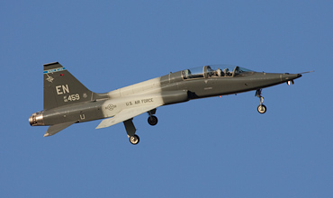
Walking from spot 1 into the field along the fence, these banking shots are the result. (Piet Luijken)
| 121.200/289.000 | Clearance Delivery |
| 125.500/289.400 | Ground |
| 119.750/279.525 | Tower |
| 120.400/269.025 | Departure |
| 118.200/269.025 | Approach |
| 132.050/269.900 | ATIS |
| 88 FTS | T-38C, "EN", silver/red tailband with "Lucky Devils" |
| 89 FTS | T-6A, "EN", red tailband with "Banshees" |
| 90 FTS | T-38C, "EN", yellow or blue tailband with "Boxing Bears" |
| 97 FTS/AFRC | T-6A, "EN", blue tailband with " Madcats" |
| 459 FTS | T-6A, "EN", green/yellow tailband with "Dragons" |
| 469 FTS | T-38A, "EN", green/yellow tailband with "Bulls" |
| 82 TRW | multiple, "ST" |
| 58-0589 | GB-52D, preserved near spot 3. |
| 62-5950 | YA-37A, preserved. |
| 63-9773 | F-111A, preserved near show parade. |
| 56-0912 | F-104C, preserved near show parade. |
| 63-7426 | F-4C, preserved near show parade. |
| 54-2151 | F-100D, code FW-151, preserved near show parade. |
| 61-0175 | F-105D, tailcode RU, preserved near show parade. |
| 80-0481 | F-16A, tailcode ST, preserved at show parade. |
| 63-8125 | T-38A, tailcode EN, preserved at show parade. |
| 77-0154 | F-15B, tailcode ST, preserved at show parade. |
| 57-0826 | F-102A, preserved. |
| 56-3520 | T-37B, tailcode EN, preserved. |
| 49-1934 | T-29A, preserved. |
| Arlington MAP | |
| Austin-Bergstrom IAP | |
| Corpus Christi-Cabaniss Field NOLF | |
| Corpus Christi-Waldron Field NOLF | |
| Dyess AFB | |
| Fort Worth - Alliance | |
| Fort Worth - Sycamore Strip | |
| Fort Worth Meacham IAP | |
| Fort Worth NAS - JRB Carswell Field | |
| Houston-Ellington Field | |
| Lackland AFB & Kelly Field | |
| Martindale AHP | |
| Orange Grove NOLF | |
| Randolph AFB | |
| Sheppard AFB - Wichita Falls MAP | |
| TSTC Waco |
As a member you get access to all our
premium content and benefits learn more