Seymour Johnson AFB

Back to Country
ICAO Code KGSB/GSB
Last Validated 03-2024
City Goldsboro
Position 35°20'24"N 077°57'35"W
Runway(s) 08/26
Elevation 110 ft

General

Seymour Johnson AFB is a vast military complex located in the middle of nowhere, next to Goldsboro, North Carolina. People in the town will definitely notice you if you drive around in a car which has a number plate out of another state, as they do not get many tourists or visitors from abroad. Seymour Johnson AFB is the place to go if you like F-15 Strike Eagles. No less than four squadrons with F-15Es are based here, together with a squadron of KC-135 tankers. You will see a whole platform packed with aircraft as about 90 Eagles can be found here. The base is ideal for spotting purposes. The base has good locations alongside the runway with sun in your back almost the whole day. Local police will tell you to stay off the gates but will not complain much about photography.

Layout

The base has one east-west runway with all facilities north of it. The V shaped dispersals are used by the Stratotankers, the large apron in the middle is used by the Strike Eagles, most of them under sunsheds nowadays, while the east aprons are used by the tankers again.

Getting There

To get to Seymour Johnson follow the I-95 and take the exit to the US-70 direction Princeton/Goldsboro. After about 35 kilometers you will reach the town. The US-70 will lead you to the front gate, which is signposted. To get to our spots, on the US-70, after passing Elroy, take a left onto Route 111.

Around the Airport

1Main Gate

At Route 111, after passing the BP gas station, take a right onto Sheridan Forest Road. Now take the second right, onto White Oak Road. When you see the fence of the base, at the turn to the left, park your car and ask permission to stand on the property of the land owners. At the gate, with a four step ladder, good shots can be made of landing traffic onto runway 26.

2Old Highway 111 road

For spot 2, after passing the BP station, take the Sheridan Forest Road exit from Road 111 and follow this until the split. Turn right on the Old Highway 111 Road and follow this to the end. The view here is quite limited. You have a good view on the runway and good pictures of the aircraft lining up can be made, but a broader view to the left and right is not possible because of the trees surrounding this spot. Another limitation is the high fence, which makes it necessary to take shots through the holes, use your four step ladder or back end of your pick up truck.

3Sheridan Forest Road

Spot 3 is at the end of Sheridan Forest Road. To arrive here, take the Sheridan Forest Road exit from Road 111 and follow this until the end. Park your car at the Road Closed signs and walk forward a bit to the fence with your four step ladder. Good shots can be made from all aircraft on the runway.

4C R Lewis Dairy Road

One of the best spots is this spot 4. To arrive here from Route 111, take the Sheridan Forest Road, take a left onto Old Highway 111 until you arrive at a V shaped junction. Take a sharp left here onto C R Lewis Dairy Road and drive to the end. Again, at the fence, for ground moving traffic, a four step ladder is needed. This is also the best spot if the Police requires you to step back from the gate.

5Tom Herring Road

This spot is good for landings onto runway 08 although it is a bit further from the runway. From spot 4, drive back, take the second right onto Tom Herring road and follow it to the end.

6Arrington Bridge Road

A spot where no-one will bother you while watching and photographing landings on runway 08. To get here, follow NC111 a bit further south than for the previous spots and then take road 581 to the right, also signposted for the base truck entrance. Follow this onto Arrington Bridge Road and continue for about 2 miles, to the junction with Pecan Road. There is a gravel track on the right where you can park and walking into the field a bit will result in an unobstructed view on approaching aircraft.

7Along I70

Comparable to spot 6 is this one, for landings on 26. Our map shows the parking lot at Wilber's Barbecue but if you want to avoid backlight for photos, a good alternative is McCall's BBQ & Seafood a bit closer to the junction with NC111. How to get here should be self-explanatory.

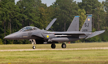
Go to the end of C R Lewis Dairy Road with your step ladder to take these kind of shots, like Peter Nieuwkamp did.

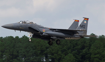
If you have permission to stand at spot 1, and you have some steps with you, you can take these kind of photos. (Peter Nieuwkamp)

Frequencies

128.025/270.800 CLNC DEL
138.100/275.800 Ground
126.250/370.875 Tower
119.700/123.700/273.600 Departure
290.900/338.600 DEP/ARR
317.625 ATIS

Preserved

53-1370/FU-972 F-86H, preserved as '112972'
53-1573 F-100A
61-0056/SJ F-105D
64-0770/SJ F-4C
74-0649/SJ F-4E
"81-0987"/FTA-10A

Other Airfields

Elizabeth City CGAS/Regional Airport  
Seymour Johnson AFB

Send Updates

Do you have updates? Or is something not listed correctly? Please let us know!
You can help us and other spotters with your information.

Subscribe to Scramble

As a member you get access to all our
premium content and benefits learn more


Follow us and keep in touch