This is a subscription only section
Want to read more? It's only €10/year.
No account yet? Just Create an account first and head to the shop
| ICAO Code | LFSC/ |
| Last Validated | 03-2012 |
| City | Colmar |
| Position | 47°55'19"N 007°23'59"E |
| Runway(s) | 01/19 |
| Elevation | 693 ft |
Colmar is located in the Alsace which clearly has a German history as shown by the German-sounding names in the area. The base is reasonably OK for spotting, although prolonged stays in the open sometimes lead to visits by the Gendarmerie. Only some Gendarmerie helicopters are based here.
The base is surrounded by mainly flat farmlands but apart from the west side, it is largely surrounded by trees so not much is visible from the outside. The farmlands include a lot of cornfields that may provide a hiding in summer, but are bare in winter. All roads leading to the perimeter in the north-east corner are off-limits for the public. The smallest roads on the map are generally unpaved.
The base is located east of the A35 from Strasbourg to Mulhouse/Basel, some 15km south of the city of Colmar. Coming from the north (city of Colmar), take exit 28 and follow the D1 to Niederhergheim. Continue to Niederentzen and Oberentzen as soon as these are posted, paralleling the autoroute. In Niederentzen, take the D18b to Rustenhart. You will pass the field on the north side. When arriving from the south (Mulhouse), use sortie 29 for Meyenheim. After crossing the autoroute, immediately turn right again and follow the D201 to Niederentzen and Oberentzen.
For the south side of the field, exit at Meyenheim for any direction of arrival by autoroute. Follow the D201 along the village and then take the D3bis towards Hirtzfelden.
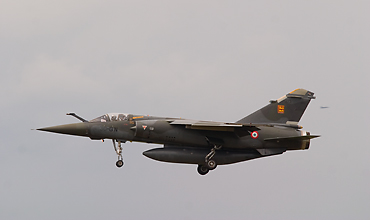
This picture of Mirage F1 275/30-QN shows the kind of shots that can be made with about 300mm. (Frank Noort)
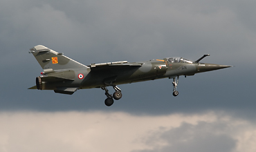
Another Mirage F1, 243/30-SN, taken at spot2 in the afternoon with 300mm on a DSLR.
| 372.800 / 122.100 | Tower |
| 257.800 | Tower |
| 372.300 / 282.175 | Approach |
| 362.300 / 118.950 | Approach |
| 336.100 | Approach (alt) |
| 141.750 / 142.450 | Approach |
| 13/'13-EC' | Mirage 3C in base museum |
| Base Aérienne 132 | Official website |
| Ambérieu (BA278) | |
| Annecy - Haute-Savoie Mont Blanc (Meythet) | |
| Avord (BA702) | |
| Bale-Mulhouse (EuroAirport) | |
| Beauvais - Tillé (Paris-Beauvais) | |
| Bordeaux - Mérignac (BA106) | |
| Bourges | |
| Cambrai - Epinoy (BA103) - CLOSED | |
| Cazaux (BA120) | |
| Châlons - Vatry | |
| Châteaudun (BA279) | |
| Châteauroux - Déols-Marcel Dassault | |
| Clermont Ferrand - Auvergne (Aulnat) | |
| Cognac - Châteaubernard (BA709) | |
| Colmar - Meyenheim (BA132) | |
| Compiègne - Margny | |
| Creil (BA110) - CLOSED | |
| Cuers - Pierrefeu | |
| Dax - Seyresse | |
| Dijon - Longvic (BA102) | |
| Etain - Rouvres | |
| Evreux - Fauville (BA105) | |
| Gap - Tallard | |
| Grenoble - Isère (St. Geoirs) | |
| Hyères - Le Palyvestre | |
| Istres - Le Tubé (BA125) | |
| La Baule-Escoublac | |
| Landivisiau | |
| Lanvéoc - Poulmic | |
| Le Luc - Le Cannet | |
| Lille - Lesquin | |
| Lorient - Lann-Bihoue | |
| Luxeuil - St. Sauveur (BA116) | |
| Lyon - Bron | |
| Lyon - Saint-Exupéry (Satolas) | |
| Marseille - Provence | |
| Metz - Frescaty (BA128) | |
| Metz-Nancy - Lorraine | |
| Mont-de-Marsan (BA118) | |
| Montauban | |
| Montpellier - Mediterrannée | |
| Nancy - Ochey (BA133) | |
| Nantes - Atlantique | |
| Nice - Côte d Azur | |
| Nîmes - Garons | |
| Orange - Caritat (BA115) | |
| Orléans - Bricy (BA123) | |
| Paris - Charles de Gaulle | |
| Paris - Issy Les Moulineaux | |
| Paris - Le Bourget | |
| Paris - Orly | |
| Pau - Pyrénées | |
| Perpignan - Rivesaltes (Llabanere) | |
| Phalsbourg - Bourscheid | |
| Pontoise - Cormeilles-en-Vexin | |
| Reims - Champagne (BA112) - CLOSED | |
| Reims - Prunay | |
| Rennes - St. Jacques | |
| Romorantin - Pruniers (BA273) | |
| Salon de Provence (BA701) | |
| Solenzara (BA126) | |
| St. Dizier - Robinson (BA113) | |
| St. Nazaire - Montoir | |
| Toulouse - Blagnac | |
| Tours - Val de Loire (BA705) | |
| Valence - Chabeuil | |
| Villacoublay - Velizy (BA107) |
As a member you get access to all our
premium content and benefits learn more