Toronto - City Centre

Back to Country
ICAO Code CYTZ/YTZ
Last Validated Jul 2007
City Toronto, Ont.
Position 43°37'39"N 079°23'46"W
Runway(s) 06/24, 08/26, 15/33
Elevation 251 ft

General

Toronto City Centre mainly serves recreational flights and flightschools. Recently, scheduled commercial flights were started. The airport also has a role in air traffic control during the Canadian International Air Show, which is held annually over Lake Ontario during Labour Day Weekend. The best spots to view the show are presented on the map as well. The short line closest to the shore is the low speed flightline, the longer one is the high speed flightline.

Layout

The airport was built in 1939 and features the typical Canadian triangle runways to deal with all kinds of weather conditions. All facilities are located to the north side of the runways.

Getting There

The airport can only be reached by the world's shortest scheduled ferry service, which runs from Bathurst Street to the airport. There is no access to the airport from one of the Toronto Islands. Directions to the other vantage points are listed under their respective bullets.

Around the Airport

1The airport

The airport has a dedicated scheduled ferry service, which operates from Bathurst Street. To reach Bathurst Street, take exit Jameson Ave when travelling eastbound on the Gardener Expressway, and exit Spadina Ave, when travelling westbound. Continue eastbound on Lakeshore Boulevard West and turn south towards the lake on Bathurst Street. In the morning photography is best for aircraft using runways 06, 08 and 15. In the late afternoon aircraft using runways 24 and 26 can be graphed from here as well.

2The shore

From the shore, flying activities can be watched as well. From Lakeshore Boulevard West, turn south towards the lake on Stadium Street, which runs parallel to Bathurst Street. At the lakeshore, turn right towards the entrance of the marina, where a small square is located. From here, traffic using runway 08/26 can be photographed later during the day. Morning landings at runway 15 are good for photography as well.

3Hanlan's Point

Despite there is no access from the Toronto Islands to the airport, viewing from one of the islands is possible. To reach the islands, take exit York Street/Bay Street off the Gardener Expressway. The ferry to Centre Island, where the airport is situated, can be found at the foot of Bay Street at the Queens Quay dock. It runs every half hour in Summer, until and inclusive the Labour Day Weekend. As the islands are car-free, you will have to park your car one block north at Lakeshore Boulevard and Bay Street. The ferry has three destinations on the islands, so make sure you take the one to Hanlan's Point. Spot 3 can be found right off the ferry dock at Hanlan's Point in the park. It gives excellent opportunities for runways 24 and 26, photography is best in the afternoon.

4Ontario Place

For those visiting the Canadian International Air Show, we have included the best vantage points to view the show in this airfield guide. Unfortunately, both viewing spots are situated on the north shore and viewing the air show to the southwest you have to deal with some backlight. The best and nearest spot to the flightlines is Ontario Place, an amusement park just south of Remembrance Drive. For eastbound access, take exit Jameson Ave off the Gardener Expressway, for westbound access, take exit Spadina Ave. Continue on Lakeshore Boulevard west, which runs parallel to Remembrance Drive, where the entrance can be found. You will have to pay a Grounds Admission fee to enter the site when viewing the air show, which is just under $20. Once on the site, head south towards to beginning of the large pier.

5Aquatic Drive

Less suitable than spot 4, but also a good spot to watch the air show is anywhere from Aquatic Drive. It can be reached by taking the same exits as Ontario Palace and is situated west of Remembrance Drive. The show is usually held in the afternoon, but you will have to come early to find a spot to park you car.

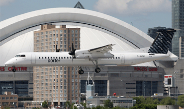
Stefan Bratner took this photo of a Porter Airlines Dash 8 from spot 3, Hanlan's Point, which gives you Toronto's city centre as background.

Frequencies

121.700Ground
118.200/119.200Tower
226.500Tower
133.400/363.800Departure
133.600ATIS
133.400/358.100Approach

Based Operators

AirspecCe441
Fox FlightCe500, Lj36
The Helicopter CompanyBell 206
National HelicoptersBell 206, Bell 212
Porter AirlinesDHC-8-400
Trans Capital AirDHC-7

More Info

CIASCanadian International Air Show

Other Airfields

Borden  
Hamilton - John C. Munro  
London Intl  
Mountain View
North Bay - Jack Garland
Ottawa - Carp
Ottawa - MacDonald-Cartier Intl  
Petawawa  
Sault Ste. Marie  
Thunder Bay  
Toronto - City Centre
Toronto - Downsview  
Toronto - Lester B. Pearson Intl  
Trenton  

Send Updates

Do you have updates? Or is something not listed correctly? Please let us know!
You can help us and other spotters with your information.

Subscribe to Scramble

As a member you get access to all our
premium content and benefits learn more


Follow us and keep in touch