This is a subscription only section
Want to read more? It's only €10/year.
No account yet? Just Create an account first and head to the shop
| ICAO Code | /MMT |
| Last Validated | 11-2011 |
| City | Eastover |
| Position | 33°55'14"N 080°48'05"W |
| Runway(s) | 05/23, 14/32 |
| Elevation | 252 ft |
The United States Army began construction on an airfield on land north of Congaree to be an outlying base to the Columbia Army Airbase. The original designation of the airfield was Congaree Army Airport, then Fort Jackson Airdrome, and finally Congree Army Airfield. Construction was completed on January 31, 1943 with the completion of three 4,500 ft runways. In September 1945, after World War II, the only remaining Marine units were VMF-523 and Air Warning Squadron 14. By November 1945, all Marine aviation units had moved to MCAS Cherry Point, North Carolina. The base was eventually turned over to the South Carolina Air National Guard and re-named McEntire ANG Base in October 1961. It was re-named McEntire Joint National Guard Station in 2005 to reflect the joint presence of Army and Air National Guard units. (source: wikipedia)
The airport has one main runway, 14/32, which is the preferential runway for the fighters and visitors. The other, smaller runway is only used by the army units. The aprons in the south are for the SC ANG fighters, while the apron in the west is used by the SC ArmyNG helicopters.
The base is located about 15 km southeast of city of Columbia. From Columbia take Highway 378 towards Oakland, Eastover and Shaw AFB. When passing the very small town of Horrel Hill, take a right onto Route 769. At the next T junction take a left onto Congaree Road and pass the ANG base at the south.
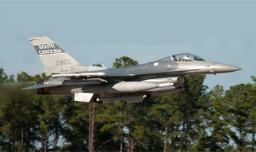
Peter Nieuwkamp took this wonderful take-off shot of a local F-16 from spot 1.
| 127.625/233.700 | Ground |
| 132.400/253.500 | Tower |
| 125.400/385.600 | Shaw Arr/Dep |
| 157th FS SC ANG | F-16C/D |
| A/2-149th AVN SC ArNG | UH-60L |
| 1-151st AVN SC ArNG | AH-64D |
| A/2-151st AVN SC ArNG | OH-58A+/C |
| det 1. B/2-238th AVN SC ArNG | CH-47D |
| SC SFD/OSACOM det.4 | C-26E |
| 75-0746 | F-16A, preserved at spot 3 |
| 51-6915/TR-915 | T-33A, preserved on ANG base |
| 53-1064/FU-064 | F-86L, preserved on ANG base |
| 53-1386 | F-86H, preserved on ANG base |
| 56-0985 | F-102A, preserved on ANG base |
| 70-1035/SC | A-7D, preserved on ANG base |
| 63-7455 | F-4C, preserved on ANG base |
| 57-0920/FG-920 | F-104C, preserved on ANG base |
| Mc Entire JNGB | |
| Shaw AFB |
As a member you get access to all our
premium content and benefits learn more