Kristiansund - Kvernberget

Back to Country
ICAO Code ENKB/KSU
Last Validated
City Kristiansund
Position 63°06'42"N 7°49'28"E
Runway(s) 07/25
Elevation 204 ft

General

Kvernberget is the international airport serving the town of Kristiansund in western Norway. It is one of no less than three international airports in Møre og Romsdal county, the others being Ålesund-Vigra and Molde-Årø. Kristiansund also serves as a heliport, serving Norwegian off-shore oil industry in the area.

Layout

Kvernberget has a single east-west runway. All facilities can be found on its north side.

Getting There

The airport is located 5 km south east of the town of Kristiansund, itself not to be mixed up with Kristiansand in southern Norway. Just follow road no.70 south and the airport will appear on your left. A bus will take you there in about 20 minutes from Kristiansund centre.

Around the Airport

1Approach 07 - north side

The airport entrance road is your first place to stop. It provides good views of aircraft approaching runway 07 or taxiing to threshold 07 for take-off. Photography is only good in the afternoon.

2Terminal area

The terminal area provides various options for viewing. First, a road to a crash gate exists, just before you reach the terminal. This spot gives great views and good pictures at the end of the day. To the left of the terminal building is a large fence, where pictures can be taken of aircraft parked on the apron. To left of the main terminal, CHC has its own terminal for ferrying oil rig crews. At various spots between the buildings, views can be obtained from aircraft and helicopters parked on the apron here.

3Approach 25 - south side

The area around the airport is covered in woods, so we need to take advantage of geography for more views. First, head to the south side of the airfield, by taking a left turn when leaving the airport entrance road for road no.70. In Byskogen, turn left again on Skogveien, which follows the runway all the way to threshold 25. At the intersection, make a sharp turn left and stop right side of the road. An open area gives limited views of aircraft approaching runway 25 from the south side; you have to act quick though, as views of flying objects are cut short by woods.

4Approach 07 - south side

To reach approach 07 from the terminal, turn left on road no.70 and right again just before the intersection with road no.680 in Byskogen. Make another right turn immediately, this road is called Omagata, keep left. After a few hundred meters, a quarry can be found on your left, and you will find yourself high above it. From here, aircraft approaching runway 07 can be seen, although they are probably a bit high and you are more or less under the approach.

5Airport overview - Kvernberget

Kvernberget is a hill just north of the airport, which provides great views of its namesake airport and the surrounding area. Enter the industrial area just west of the airport, which is situated right off road no.70. Take a right turn at the roundabout, you are now on Industriveien. Turn left at the T-junction, heading north. Go as far as you can by car and follow the road by foot all the way to the top. Enjoy the view!

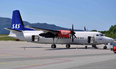
SAS Fokker parked near the terminal as seen from spot 2. Michael van der Plas.

Frequencies

118.300 / 121.200Tower

Based Operators

Civil companies
CHC NorwayAS332
EC225
S-92

More Info

Kristiansund Lufthavn, KvernbergetKristiansund airport on Avinor website

Other Airfields

Ålesund - Vigra  
Bardufoss  
Bergen - Flesland
Bodø
Haugesund - Karmøy (Helganes)
Kristiansand - Kjevik  
Kristiansund - Kvernberget
Molde - Årø  
Oslo - Gardermoen  
Oslo - Kjeller  
Rygge (Moss)  
Sandefjord - Torp
Skien - Geiteryggen  
Stavanger - Sola  
Tromsø - Langnes  
Ørland

Send Updates

Do you have updates? Or is something not listed correctly? Please let us know!
You can help us and other spotters with your information.

Subscribe to Scramble

As a member you get access to all our
premium content and benefits learn more


Follow us and keep in touch