This is a subscription only section
Want to read more? It's only €10/year.
No account yet? Just Create an account first and head to the shop
| ICAO Code | EHKD/DHR |
| Last Validated | Feb 2014 |
| City | Den Helder |
| Position | 52°55'24"N 004°46'50"E |
| Runway(s) | 03/21 |
| Elevation | 3 ft |
Since the closure of Valkenburg NAS, this is the remaining naval aviation base in Holland. Because the harbour of Den Helder is the main base for Dutch navy ships, the NH90 helicopters are based here. The airfield attracts visiting helicopters from other countries, both civil and military, and the occasional transport aircraft. Part of the field is civil and houses several helicopter companies and some general aviation. Dancopter and CHC perform the majority of movements and are off-shore flights.
The terrain is flat and open with a lot of canals and ditches. With some moving around on several sides of the airport anything parked outside or flying should come into view.
By car, use any of the three major roads coming together just southeast of the field to reach the area. Do not take the main road N250 towards Den Helder, but take the feeder road which starts at the McDonalds. Drive on this road called Doggersvaart to drive along the airport. There is an exit towards the civil terminal and another one towards the military area. Public transport gives two options. Den Helder Zuid train station is about a 25 minute walk from the field, and the Interliner bus from Den Helder's main railway station stops at the base.
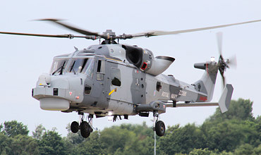
British Wildcat arriving at De Kooy for a fuel stop, enroute to Nordholz. (Edwin Daalder)

This Norwegian NH90 was visiting its Dutch colleagues and captured near the terminal, spot 2. (Martin Schmitz)
| 121.730 | Ground |
| 379.750 | Ground / Tower |
| 120.130 | Tower |
| 372.150 / 124.230 | Arrival |
| 359.100 / 123.305 | Spare |
| 301.200 | De Kooy Operations |
| 264.325 / 132.350 | Dutch Mil |
| Civil operators: | |
| CHC Helicopters Netherlands | AW139, AW189 |
| Noordzee Helikopters Vlaanderen | AS365N, AW139, EC155, H175 |
| Bel Air | AW139, AW189 |
| Military operators: | |
| DHC (7sq & 860sq) | NH90-NFH |
| '118/D' | Actually WV828, this former Royal Navy Sea Hawk is painted in Dutch colours. |
| '235/K' | Also a former RN example, the serial of this Wasp is really XT795. Both are preserved inside a building at the base. |
| 220 | AB204, in front of new building, visible from the main gate |
| 216/V | SP-2H, former gate guard from Valkenburg has moved to an area close to the military gate. |
| 184 | CS-2A, preserved on base |
| Den Helder Airport | The official site of Den Helder Airport |
| Royal Dutch Navy | The site of the Dutch Navy Air Operations |
| Spotting group De Kooy | The site of the Spotters Group De Kooy |
| Traditiekamer MLD | site of the Naval Museum on the military part of this airfield. |
| Scramble Message Board | Den Helder-De Kooy forum |
| Royal Netherlands Air Force/Navy |
| Coast Guard Netherlands |
| Ameland | |
| Amsterdam - Schiphol | |
| Budel (Kempen Airport) | |
| De Peel | |
| Deelen | |
| Den Helder/De Kooy | |
| Eindhoven | |
| Gilze-Rijen | |
| Groningen/Eelde | |
| Hilversum | |
| Hoogeveen | |
| Leeuwarden | |
| Lelystad | |
| Maastricht-Aachen | |
| Midden-Zeeland | |
| Rotterdam-The Hague | |
| Soesterberg - CLOSED | |
| Teuge | |
| Texel | |
| Twente | |
| Valkenburg - CLOSED | |
| Volkel | |
| Woensdrecht |
As a member you get access to all our
premium content and benefits learn more